 Metadata Catalogue
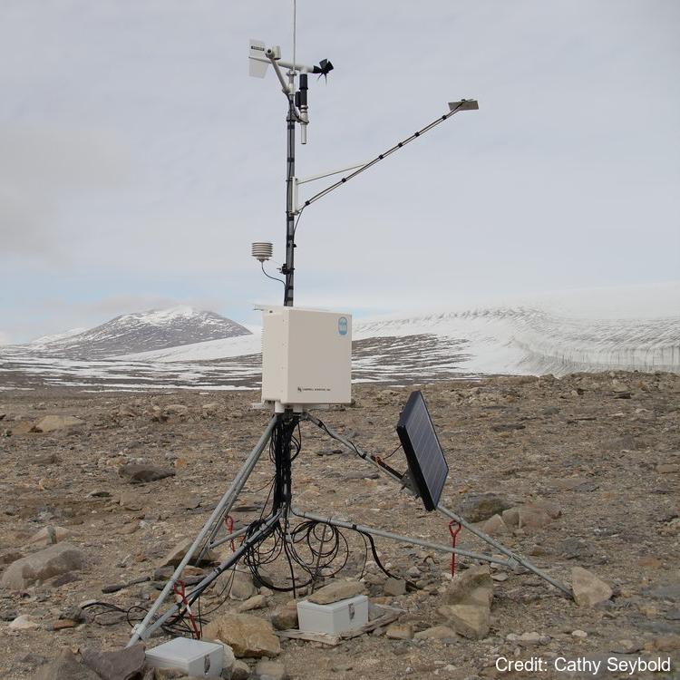
Soil Climate and Atmospheric Data at Scott Base, Marble Point, Mount Fleming, Bull Pass, Granite Harbour, Minna Bluff, Victoria Valley, Don Juan Pond and Bull Pass East, Antarctica
Simple
Identification info
- Date (Creation)
- 2023-08-10T16:56:18
- Date (Publication)
- 2023-08-10T16:56:18
- Presentation form
- Status
- On going
- Point of contact - Custodian, Owner, etc
-
Role Organisation Individual Electronic mail address Publisher United States Department of Agriculture
- Spatial representation type
- Topic category
-
- Climatology, meteorology, atmosphere
- Geoscientific information
Extent
))


Temporal extent
- Time period
- 1999-04-01T00:00:00
- Maintenance and update frequency
- As needed
- Date
- 2023-08-10T16:56:24
- Date type
- Last Update
- GCMD Earth Science and Earth Science Services Keywords
-
-
SOLAR RADIATION
-
ACTIVE LAYER
-
SOIL TEMPERATURE
-
AIR TEMPERATURE
-
HUMIDITY
-
SURFACE WINDS
-
WATER VAPOR
-
SOIL MOISTURE
-
- GCMD Platform/Sources Keywords
-
-
WEATHER STATIONS
-
- GCMD Instrument/Sensors Keywords
-
-
SOIL TEMPERATURE PROBE
-
AWS
-
SOIL MOISTURE PROBE
-
- GCMD Locations Keywords
-
-
ANTARCTICA
-
ROSS ISLAND
-
- Theme
-
-
SCOTT BASE
-
MARBLE POINT
-
MOUNT FLEMMING
-
BULL PASS
-
GRANITE HARBOUR
-
MINNA BLUFF
-
VICTORIA VALLEY
-
DON JUAN POND
-
BULL PASS
-
MCMURDO DRY VALLEYS
-
INSTALLATION
-
K881B
-
- Resource constraints
-
Legal constraints Access constraints Use constraints Constraint application scope This data set conforms to the CC BY-NC Attribution License ( https://creativecommons.org/licenses/by-nc/4.0/ )
License License Dataset
Associated resource
- Association Type
- Cross reference
- Initiative Type
- Collection
Associated resource
- Association Type
- Cross reference
- Initiative Type
- Collection
Associated resource
- Association Type
- Cross reference
- Initiative Type
- Collection
- Language
- English
- Character encoding
- UTF8
Distribution Information
- Distribution format
-
- Metadata constraints
-
Legal constraints Access constraints Use constraints Constraint application scope This data set conforms to the CC BY-NC Attribution License ( https://creativecommons.org/licenses/by-nc/4.0/ )
License License Metadata
Metadata
- Metadata identifier
- urn:uuid/6bc04f66-3e79-4591-9030-0016fe8dbd27
- Language
- English
- Character encoding
- anyValidURI
- Metadata Contact
-
Role Organisation Individual Electronic mail address Point of contact Manaaki Whenua Landcare Research
Type of resource
- Resource scope
- Dataset
- Metadata linkage
-
Name Linkage (URL) Protocol Function Description https://www.nrcs.usda.gov/resources/data-and-reports/soil-climate-research-stations
Complete Metadata
- Date info (Revision)
- 2026-03-31T21:42:41.536Z
- Date info (Creation)
- 2023-08-10T04:55:13
Metadata standard
- Format name
-
ISO 19115-1
- Edition
-
2018