 Metadata Catalogue
ASP
Type of resources
Topics
Keywords
Contact for the resource
Provided by
Years
Update frequencies
status
-

This metadata record represents the R phytoclass package. Determine the chlorophyll a (Chl a) biomass of different phytoplankton groups based on their pigment biomarkers. The method uses non-negative matrix factorisation and simulated annealing to minimise error between the observed and estimated values of pigment concentrations (Hayward et al. (2023) https://doi.org/10.1002/lom3.10541). The approach is similar to the widely used 'CHEMTAX' program (Mackey et al. 1996) https://doi.org/10.3354/meps144265), but is more straightforward, accurate, and not reliant on initial guesses for the pigment to Chl a ratios for each phytoplankton group. Further details are provided at: Hayward, A., M. H. Pinkerton, and A. Gutierrez-Rodriguez. 2023. phytoclass: A pigment-based chemotaxonomic method to determine the biomass of phytoplankton classes. Limnol. Oceanogr. Methods 21: 220–241. https://doi.org/10.1002/lom3.10541 GET PACKAGE: https://cran.r-project.org/web/packages/phytoclass/readme/README.html
-
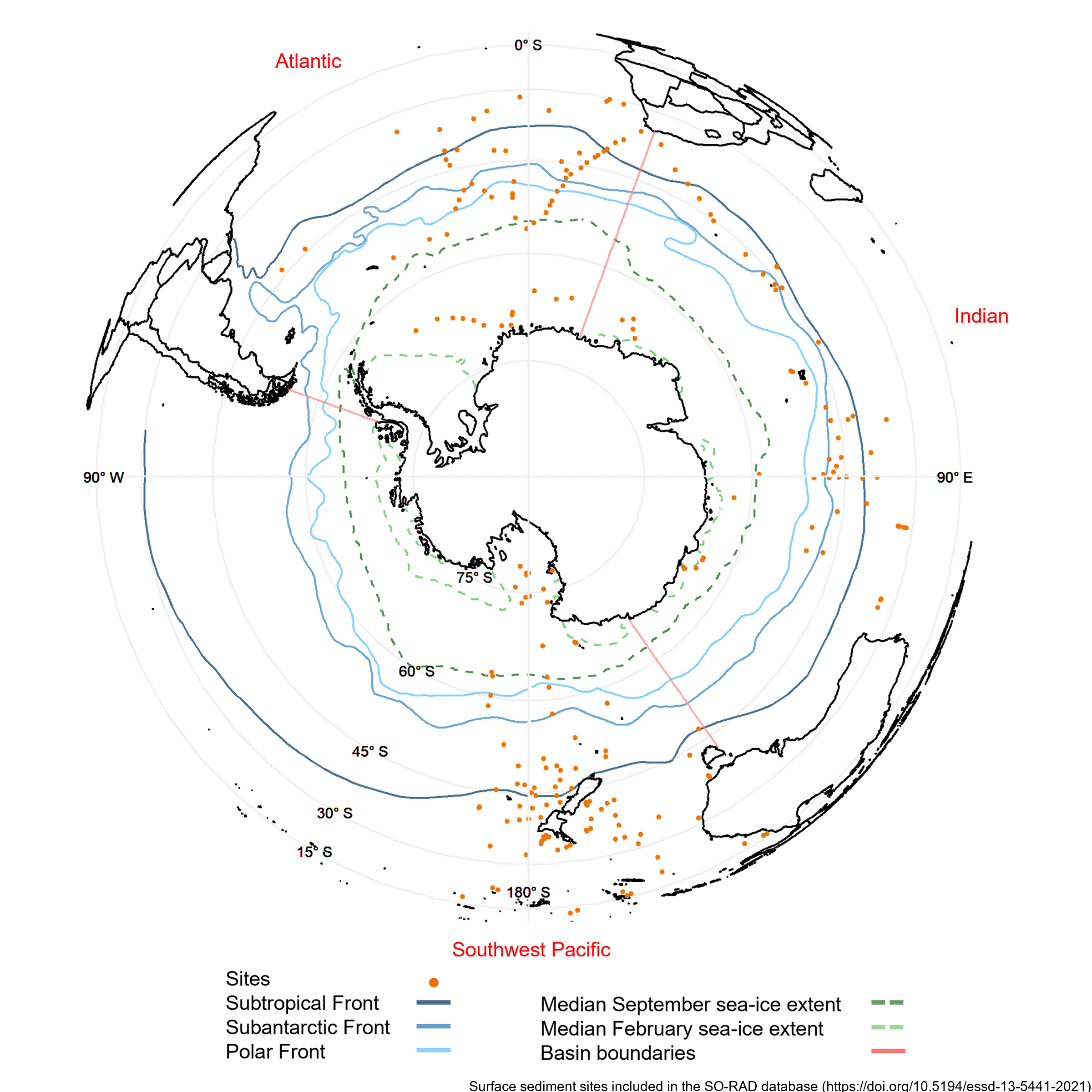
Radiolarians (holoplanktonic Protozoa) found in marine sediments are commonly used in Southern Ocean as palaeoclimate proxies. Generating such reconstructions of past climate based on radiolarian abundances requires a spatially and environmentally comprehensive reference dataset of modern radiolarian census counts. The Southern Ocean RADiolarian (SO-RAD) dataset includes census counts for 237 radiolarian taxa from 228 surface sediment samples located in the Atlantic, Indian and South-west Pacific sectors of the Southern Ocean. This compilation is the largest radiolarian census dataset derived from surface sediment samples in the Southern Ocean. The SO-RAD dataset may be used as a reference dataset for palaeoceanographic reconstructions, or for studying modern radiolarian biogeography and species diversity. RELATED PUBLICATION: https://doi.org/10.5194/essd-13-5441-2021
-
AntAir ICE is an air temperature dataset for terrestrial Antarctica, the ice shelves, and the seasonal sea ice around Antarctica in a 1km2 spatial grid resolution and a daily temporal resolution available from 2003-2021. AntAir ICE was produced by modelling air temperature from MODIS ice surface temperature and land surface temperature using linear models. In-situ measurements of air temperature from 117 Automatic Weather Stations were used as the response variable. Each day has a bricked spatial raster with two layers, saved as a GeoTIFF format and in the Antarctic Polar Stereographic projection (EPSG 3031). The first layer is the predicted near surface air temperature for that day in degree Celsius * 10 and the second layer is the number of available MODIS scenes for that day ranging from 0 to 4. Areas with cloud contamination or without sea ice are marked with no data. Files for each year (2003-2021) are compressed with a ZIP files for each quarter. Python 3.8 was used for conversion of the MODIS products from HDF files to raster and all data handling and processing was thereafter done in R version 4.0.0. All data processing and modelling procedures are available as R scripts on a public Github repository: https://github.com/evabendix/AntAir-ICE. Using this code it is possible to download new available MODIS LST and IST scenes and apply the model to continue the near-surface air temperature dataset. Related Publication: https://doi.org/10.1038/s41597-023-02720-z GET DATA: https://doi.org/10.1594/PANGAEA.954750
-
This data publication contains biostratigraphic age events for the CIROS-1 drill core, updated age ranges for a suite of samples from the McMurdo erratics sample collection, age-depth tie points for CIROS-1, CRP-2/2A, DSDP 270, DSDP 274, ANDRILL 2A and ANDRILL 1B, and glycerol dialkyl glycerol tetraethers (GDGTs) abundances and indices for samples from the McMurdo erratics, CIROS-1, CRP-2/2A, DSDP 270, DSDP 274, ANDRILL 2A, and ANDRILL 1B. All sample sites are in the Ross Sea region of Antarctica. The McMurdo erratics are glacial erratics collected in the McMurdo Sound region between 1991 and 1996 (Harwood and Levy, 2000). The CIROS-1 drill core was collected from McMurdo sound in 1986 with samples spanning the upper Eocene to lower Miocene. CRP-2/2A drill core was collected in 1999 from offshore Victoria Land with samples for this study from the upper Oligocene-lower Miocene. DSDP Site 270 was recovered from the Eastern Basin of the central Ross Sea in 1973, with samples spanning the upper Oligocene-lower Miocene. DSDP Site 274 was drilled on the lower continental rise in the northwestern Ross Sea in 1973, and samples for this study have been taken from the middle Miocene sections of the drill core. The ANDRILL-2A core was recovered in 2007 from Southern McMurdo Sound, samples span the lower Miocene to middle Miocene and data was originally published in Levy et al. (2016). The ANDRILL-IB core was drilled from the McMurdo Ice Shelf in 2006, samples are compiled from the Plio-Pleistocene section of the core and were originally published in McKay et al. (2012). Biostratigraphic age events are described for CIROS-1, expanding on and updating previously published age models and biostratigraphic ranges. Ages are also revised for the McMurdo erratics by updating the ages of the biostratigraphic markers described by (Harwood and Levy (2000) to more recently published age ranges. Age models for the sample sites are developed using published age datums and the Bayesian age-depth modelling functionality in the R package Bchron (Haslett and Parnell, 2008) to ensure a consistent approach for assigning ages to core depths between datums. GDGT abundances and indices for Ross Sea sites are presented to reconstruct ocean temperatures over the Cenozoic era. Detailed methodology for the processing and analysis of samples for GDGTs is described in the methods section of supplement paper.
-
Diatom census counts were used to quantitatively estimate summer sea-surface temperatures (SST) over the last 40,000 years in core MD11-3353, collected in 2011 on board the R.V. Marion Dusfresne west of Kerguelen Island, Southern Ocean. The transfer function used to reconstruct summer (January to March) SST is the Modern Analog Technique that here uses 249 surface sediment samples (modern analogs), the relative abundances of 32 diatom species and the chord distance to select the five most similar modern analogs (Crosta et al., 2020). This method yields a root mean square error of prediction of ~1 °C. The core chronology is detailed in Thöle et al. (2019). RELATED PUBLICATION: Civel-Mazens, Matthieu; Crosta, Xavier; Cortese, Giuseppe; Michel, Elisabeth; Mazaud, Alain; Ther, Olivier; Ikehara, Minoru; Itaki, Takuya (2021): Impact of the Agulhas Return Current on the oceanography of the Kerguelen Plateau region, Southern Ocean, over the last 40 kyrs. Quaternary Science Reviews, 251, 106711, https://doi.org/10.1016/j.quascirev.2020.106711
-
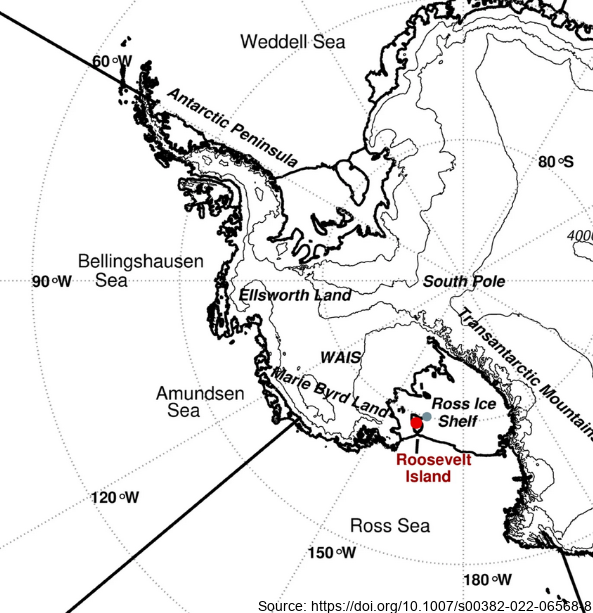
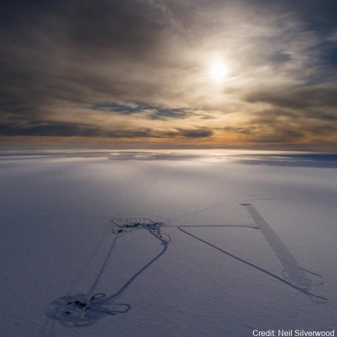
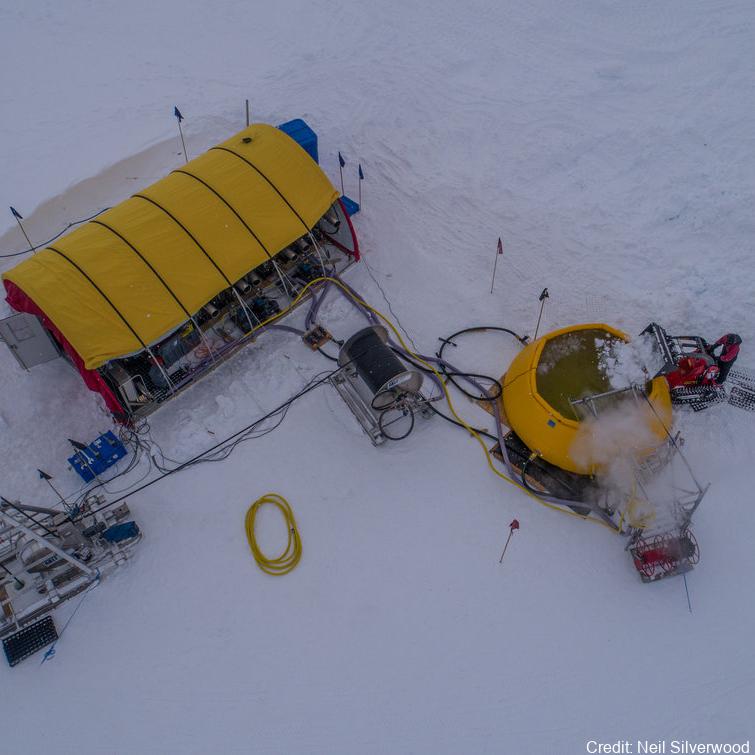
Here we examine the water stable-isotope data from the Roosevelt Island Climate Evolution (RICE) ice core. In this study, we use empirical orthogonal function (EOF) analysis to investigate the relationship between RICE ice-core oxygen-18 isotopes (δ18O) and Southern Hemisphere atmospheric circulation during the extended austral winter (April–November). - Deep Location: 79.364°S, 161.706°W, elevation 550 m a.s.l. - 12/13B Location: 79.362°S, 161.698°W, elevation 550 m a.s.l. - Core depth 763 m. Depth interval provided here: 1.29 to 38.56 m - txt data file, NaN = no data Further details are available at https://doi.org/10.1007/s00382-022-06568-8 GET DATA: https://github.com/demanuelsson/ClimDyn_2022_Matlab/tree/main/data
-
This metadata record represents the data for generated by mining single-cell genomic, transcriptomic, and metagenomic data to uncover the viral diversity, biogeography, activity, and their role as metabolic facilitators of microbes beneath the Ross Ice Shelf. Hot drilling and seawater sampling was conducted from the sub-shelf water column in the central region of the RIS (Latitude −80.6577 N, Longitude 174.4626 W). The sampling site was located ≈300 km from the shelf front. A borehole (30 cm diameter) conducted by hot water drilling was used for direct sampling of seawater from three depths (400 m, 550 m, and 700 m from the top of the shelf, which correspond to 30 m, 180 m, and 330 m from the bottom of the ice shelf, respectively). Seawater samples were processed accordingly for single cell genomics, metagenomics, and transcriptomics as described5, and the resulting assembled and co-assembled contigs (min. length 1 kb) from single-amplified genomes, bins and transcriptomics were mined for detecting viral contigs. Further details are provided at https://doi.org/10.1038/s41467-023-44028-x GET DATA: https://doi.org/10.6084/m9.figshare.24581331
-
In Antarctica, ice shelves such as the Ross Ice Shelf (RIS) fringe 75% of the coastline and cover over 1.5 million km2, creating distinct and largely unexplored marine environments. It is fundamental to characterize the communities under these shelves to understand their biogeochemical role and predict how they might respond to future ice-shelf collapse 1,2. While historical studies suggested the RIS harbors active microorganisms 3–5, nothing is known about the composition of these communities. In this study, we profiled the composition, function, and activities of microbial communities in three seawater samples (400, 550, 700 m depth) underlying the shelf interior. We combined rate measurements with multi-omics (i.e. single-cell genomics, metagenomics, metatranscriptomics, and metaproteomics). Overall, below-shelf waters harbour microbial communities of comparable abundance and diversity to deep pelagic waters. Based on the meta-omic data, the community is inferred to be sustained by dark carbon fixation using ammonia, nitrite, and sulfur compounds as electron donors. In turn, these chemolithoautotrophs are predicted to support the aerobic heterotrophic majority and various trophic interactions. Consistently, this study and previous activity measurements suggest that dark carbon fixation is sufficient to sustain prokaryotic heterotrophic production, making the waters below the RIS presumably the largest chemolithotrophic system in the global ocean. Further details are provided at https://doi.org/10.1038/s41467-021-27769-5 GET DATA: https://www.ebi.ac.uk/ena/browser/view/PRJEB35712 GET DATA: https://www.ncbi.nlm.nih.gov/bioproject/?term=PRJNA593264
-

The data is generated through modelling simulations using the University of Victoria Earth system climate model. The modelling dataset presented here corresponds to the study entitled "Transient response of Southern Ocean ecosystems during Heinrich stadials". This dataset contains data files of the complete transient simulations (FW,FE and FWFE) and 40ka-control simulation mentioned in Table 1 and Table 2 of the manuscript. We first performed a control simulation 40ka-control integrating a total of 10000 years. We use only the last 200 years of this control simulation for our analysis. The data is generated through modelling simulations using the University of Victoria Earth system climate model. All the final data is in nc format, which can be easily read by Python/ferret or any other common data analysing software. RELATED PUBLICATION: Saini,H., Meissner,K.J., Menviel,L., & Kvale,K.(2024). Transient response of Southern Ocean ecosystems during Heinrich stadials. Paleoceanography and Paleoclimatology, 39, e2023PA004754. https://doi.org/10.1029/2023PA004754 GET DATA: https://doi.org/10.5061/dryad.k3j9kd5dt
-
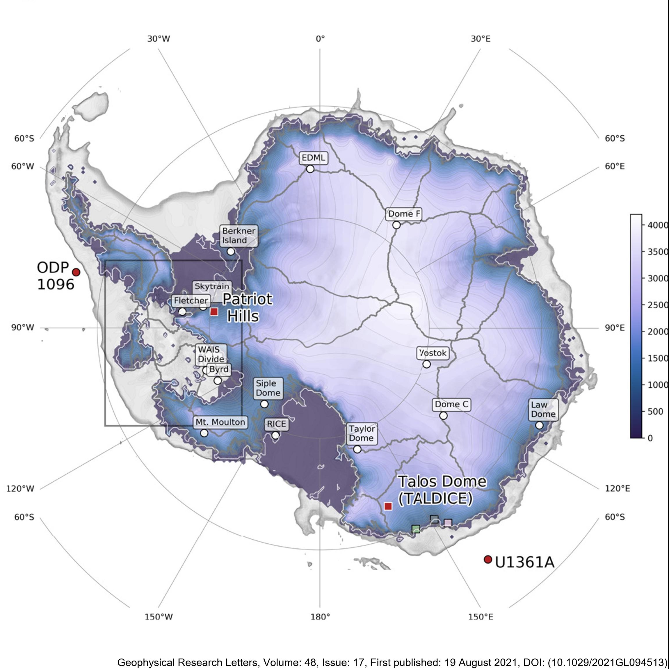
Here, we present new, transient, GCM-forced ice-sheet simulations validated against proxy reconstructions. This is the first time such an evaluation has been attempted. Our empirically constrained simulations indicate that the AIS contributed 4 m to global mean sea level by 126 ka BP, with ice lost primarily from the Amundsen, but not Ross or Weddell Sea, sectors. We resolve the conflict between previous work and show that the AIS thinned in the Wilkes Subglacial Basin but did not retreat. We also find that the West AIS may be predisposed to future collapse even in the absence of further environmental change, consistent with previous studies. There are two files, for Termination 1 ('T1') and Termination 2 ('T2'). They contain spatial fields for ice thickness, ice surface elevation, bedrock elevation, surface and basal velocity, and mask. The T1 outputs are every 500 years, whereas the T2 outputs are every 100 years. The spatial resolution of both is 20 km. Sea-level-equivalent mass loss can be calculated from these outputs, but is also provided here in a text file for convenience. RELATED PUBLICATION: Golledge, N.R., Clark, P.U., He, F., et al. (2021). Retreat of the Antarctic Ice Sheet During the Last Interglaciation and Implications for Future Change. Geophysical Research Letters, 48(17). https://doi.org/10.1029/2021GL094513 GET DATA: https://doi.org/10.17605/OSF.IO/GZB3H