 Metadata Catalogue
notPlanned
Type of resources
Topics
Keywords
Contact for the resource
Provided by
Years
Update frequencies
status
-
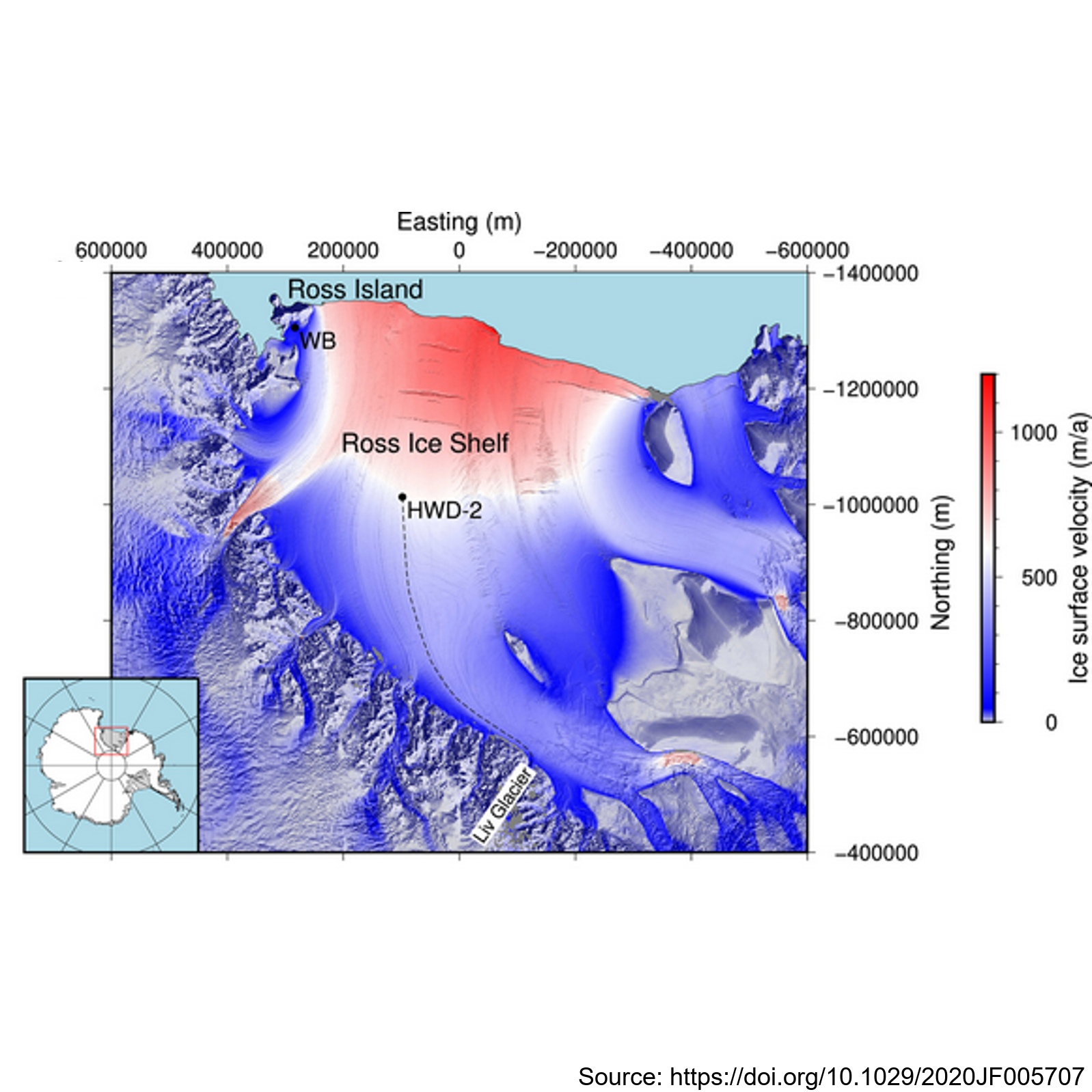
This metadata record presents observations of ice shelf anisotropy derived from borehole seismic data. Hot-water-drilled boreholes were created at two sites: Windless Bight (WB) near the grounding line on Ross Island and HWD-2 in the central Ross Ice Shelf. The boreholes housed seismometers frozen at various depths within the ice, enabling seismic observations of shear wave splitting (SWS) using active seismic sources. At Windless Blight, borehole seismometers were installed at depths of 40 and 190 meters within the ∼220 m thick ice shelf during the 2016/2017 Antarctic field season. Seismic shots were recorded with a 2,000 Hz sampling rate and a 2 s record length, triggered by striking plates. The site was revisited in December 2017 to validate sensor survivability and reproduce survey geometry for SWS analysis using multiazimuth shots. At HWD-2, eight seismometers were deployed at depths ranging from 80 to 325 meters inside the ∼370 m thick ice shelf during the 2017/2018 field season. A total of 747 shots at 53 different shot points were recorded, with clear observations of split shear waves in the data. The study contributes valuable seismic data and methodology for understanding ice shelf anisotropy, enhancing our knowledge of Antarctic ice dynamics and seismic behavior. Further details are provided at: Lutz, F., Eccles, J., Prior, D. J., Craw, L.,Fan, S., Hulbe, C., et al. (2020). Constraining ice shelf anisotropy using shear wave splitting measurements from active‐source borehole seismics.Journal of Geophysical Research: EarthSurface,125, e2020JF005707. https://doi.org/10.1029/2020JF005707 GET DATA: https://auckland.figshare.com/s/9f783802272b825d7ad7
-

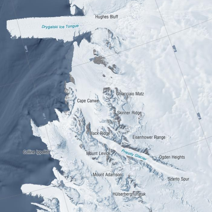
These data were aquired with a Terrestrial Radar Interferometer overlooking the grounding zone of Priestley Glacier, Antarctica. The time series contains differential interferograms with a 12h temporal baseline covering an approximately 8 day period in November 2018. Tidal modulation of ice streams and their adjacent ice shelves is a real-world experiment to understand ice-dynamic processes. We observe the dynamics of Priestley Glacier, Antarctica, using Terrestrial Radar Interferometry (TRI) and GNSS. Ocean tides are predominantly diurnal but horizontal GNSS displacements oscillate also semi-diurnally. The oscillations are strongest in the ice shelf and tidal signatures decay near-linearly in the TRI data over >10 km upstream of the grounding line. Tidal flexing is observed >6 km upstream of the grounding line including cm-scale uplift. Tidal grounding line migration is small and <40 % of the ice thickness. The frequency doubling of horizontal displacements relative to the ocean tides is consistent with variable ice-shelf buttressing demonstrated with a visco-elastic Maxwell model. Taken together, this supports previously hypothesized flexural ice softening in the grounding-zone through tides and offers new observational constraints for the role of ice rheology in ice-shelf buttressing. Time series of line-of-sight flowfields averaged over approximately three hours. Data were taken with a Terrestrial Radar Interferometer in November 2018 at the grounding zone of Priestley Glacier, Antarctica – The Zip Archive contains 288 Geotiff in South polar stereographic projection – Each raster has 4027 x 4746 entries – The file name details the approximately 3h time inverval of aquisition with Stack_YYYYMMDD_HHMMSS_YYYYMMDD_HHMMSS marking the beginning and end of the time interval, respectively. – The line of sight velocities are given in meters per year Related Publication: Drews, R., Wild, C. T., Marsh, O. J., Rack, W., Ehlers, T. A., Neckel, N., & Helm, V. (2021). Grounding-zone flow variability of Priestley Glacier, Antarctica, in a diurnal tidal regime. Geophysical Research Letters, 48, e2021GL093853. https://doi.org/10.1029/2021GL093853 GET DATA: https://doi.org/10.1594/PANGAEA.935702
-

This is GNSS data of four stations covering the grounding zone of Priestley Glacier Antarctica. Tidal modulation of ice streams and their adjacent ice shelves is a real-world experiment to understand ice-dynamic processes. We observe the dynamics of Priestley Glacier, Antarctica, using Terrestrial Radar Interferometry (TRI) and GNSS. Ocean tides are predominantly diurnal but horizontal GNSS displacements oscillate also semi-diurnally. The oscillations are strongest in the ice shelf and tidal signatures decay near-linearly in the TRI data over >10 km upstream of the grounding line. Tidal flexing is observed >6 km upstream of the grounding line including cm-scale uplift. Tidal grounding line migration is small and <40 % of the ice thickness. The frequency doubling of horizontal displacements relative to the ocean tides is consistent with variable ice-shelf buttressing demonstrated with a visco-elastic Maxwell model. Taken together, this supports previously hypothesized flexural ice softening in the grounding-zone through tides and offers new observational constraints for the role of ice rheology in ice-shelf buttressing. Related Publication: Drews, R., Wild, C. T., Marsh, O. J., Rack, W., Ehlers, T. A., Neckel, N., & Helm, V. (2021). Grounding-zone flow variability of Priestley Glacier, Antarctica, in a diurnal tidal regime. Geophysical Research Letters, 48, e2021GL093853. https://doi.org/10.1029/2021GL093853 GET DATA: https://doi.pangaea.de/10.1594/PANGAEA.936090
-
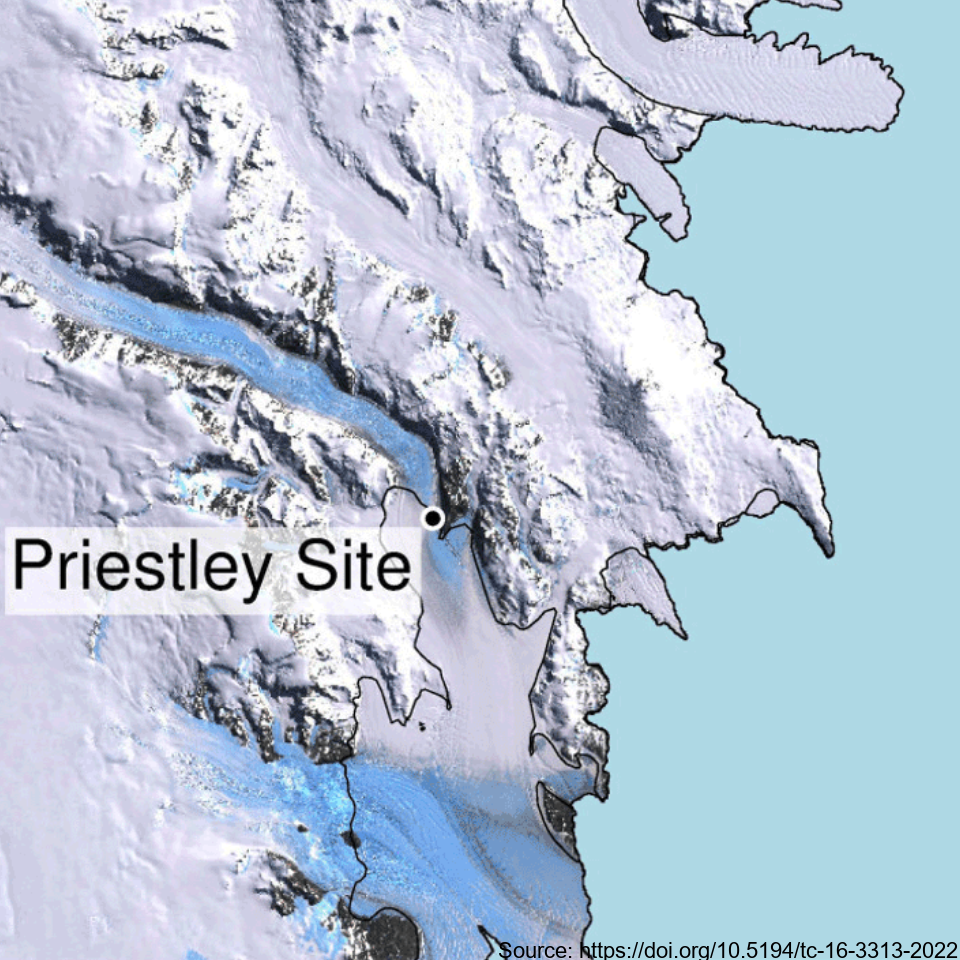
This metadata record represents the first direct comparison of seismic and ultrasonic data with measured crystallographic preferred orientations Crystallographic preferred orientations (CPO) in a polar shear margin (Priestly Glacier, Antarctica). Analyses of seismic, ultrasonic and measured CPO datasets were combined to assess the potential of active-source seismic surveys for the constraint of shear margin anisotropy, which provide an assessment of ice flow dynamics and stability. A continuous ice core of 58 m length was drilled and recovered in December 2019 and January 2020 in a lateral shear margin of the Priestley Glacier, located in Victoria Land, Antarctica. Core samples were analysed for CPO using electron backscatter diffraction (EBSD) measurements. The core orientation was carefully preserved during drilling, which enabled azimuthal orientation of the CPO. To complete the link between seismic anisotropy of the ice volume around the borehole and CPO measurements from the core, multi-azimuthal ultrasonic velocity measurements were made on core samples in the laboratory. The vertical-seismic-profile (VSP) dataset was recorded at the Priestley drill site using a three-component borehole seismometer to investigate seismic properties and anisotropy within the glacier ice. Additionally, multi-azimuthal ultrasonic velocity measurements were conducted on core samples in the laboratory, complementing the seismic data analysis. Further details are provided at: Lutz, F., Prior, D.J., Still, H., Hamish Bowman, M., Boucinhas, B., Craw, L., Fan, S., Kim, D., Mulvaney, R., Thomas, R.E., & Hulbe, C.L. (2022). Ultrasonic and seismic constraints on crystallographic preferred orientations of the Priestley Glacier shear margin, Antarctica. *Cryosphere*, 16(8), 3313-3329. https://doi.org/10.5194/tc-16-3313-2022 GET DATA: https://auckland.figshare.com/articles/dataset/Priestley_Glacier_seismic_and_ultrasonic_constraints_on_crystallographic_orientation/17108639
-

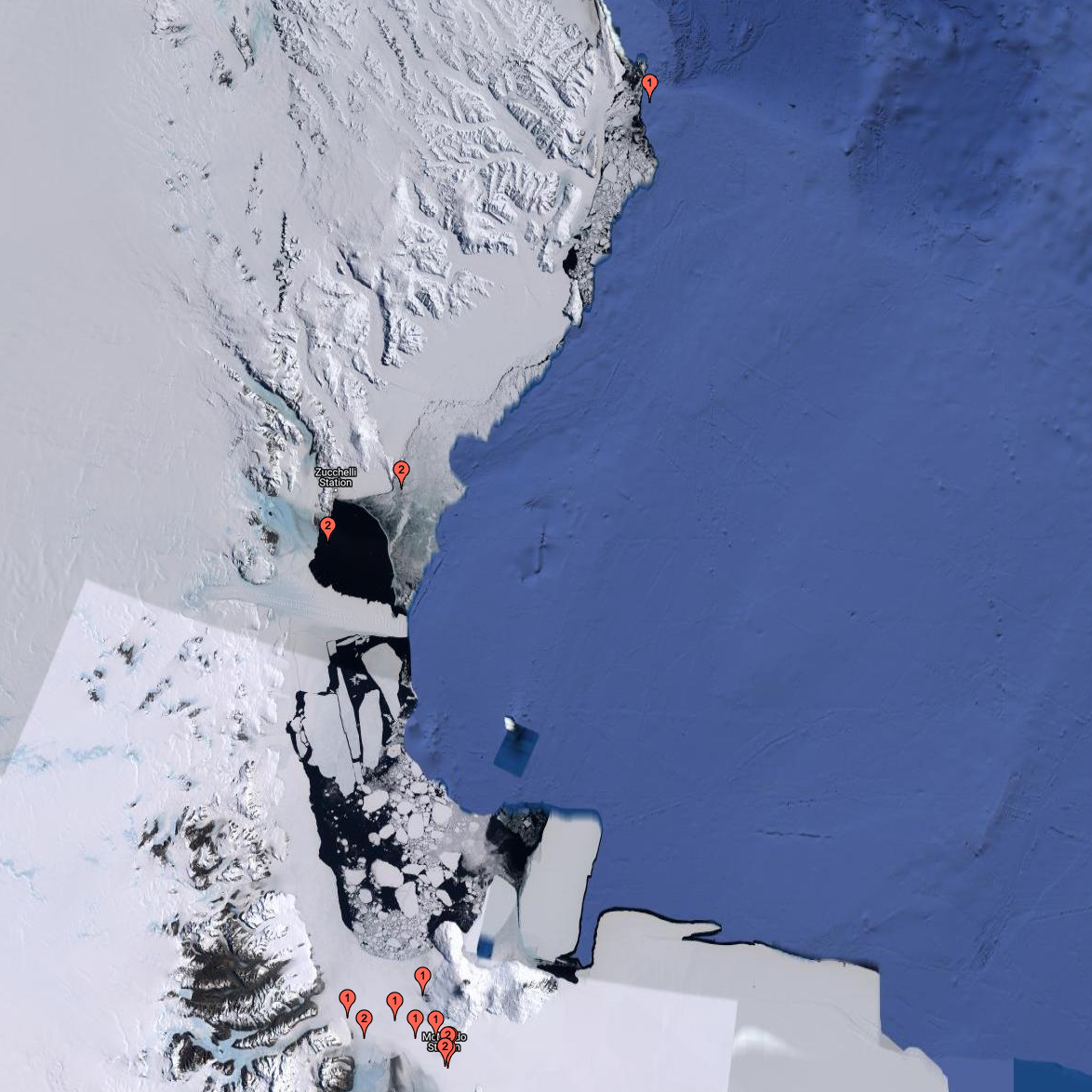
Here, we present drill hole measurements carried out at 14 field sites distributed over a ~1500 km^2 area of fast ice in the south of McMurdo Sound, Antarctica between 1 and 19 November 2018. At each site, five holes were drilled in the fast ice at the centre and end points of two cross‐profile lines, each 30 metre long. Sea ice and SIPL thicknesses were measured with a suspended thickness probe and metal bar using the procedure described in Price et al. (2014). Snow depth measurements at centimetre accuracy were made at half‐metre intervals along the cross‐profiles using a metal ruler or a GPS‐equipped Magnaprobe. Sea ice freeboard (i.e., the height of the sea ice surface above sea level) was measured in each of the drill holes. The average value for each parameter was calculated at each field site to provide a representative measurement over the 30 metre cross-profile fast ice area. The drill hole measurements were used to underpin spatial distribution surveys of the aforementioned parameters, to inform electromagnetic induction forward and inverse models, and to ground-validate satellite altimetry assessments of fast ice freeboard and derived ice thickness in McMurdo Sound.
-
These data were aquired with a Terrestrial Radar Interferometer overlooking the grounding zone of Priestley Glacier, Antarctica. The time series contains differential interferograms with a 12h temporal baseline covering an approximately 8 day period in November 2018. Tidal modulation of ice streams and their adjacent ice shelves is a real-world experiment to understand ice-dynamic processes. We observe the dynamics of Priestley Glacier, Antarctica, using Terrestrial Radar Interferometry (TRI) and GNSS. Ocean tides are predominantly diurnal but horizontal GNSS displacements oscillate also semi-diurnally. The oscillations are strongest in the ice shelf and tidal signatures decay near-linearly in the TRI data over >10 km upstream of the grounding line. Tidal flexing is observed >6 km upstream of the grounding line including cm-scale uplift. Tidal grounding line migration is small and <40 % of the ice thickness. The frequency doubling of horizontal displacements relative to the ocean tides is consistent with variable ice-shelf buttressing demonstrated with a visco-elastic Maxwell model. Taken together, this supports previously hypothesized flexural ice softening in the grounding-zone through tides and offers new observational constraints for the role of ice rheology in ice-shelf buttressing. Related Publication: Drews, R., Wild, C. T., Marsh, O. J., Rack, W., Ehlers, T. A., Neckel, N., & Helm, V. (2021). Grounding-zone flow variability of Priestley Glacier, Antarctica, in a diurnal tidal regime. Geophysical Research Letters, 48, e2021GL093853. https://doi.org/10.1029/2021GL093853 GET DATA: https://doi.org/10.1594/PANGAEA.935707
-
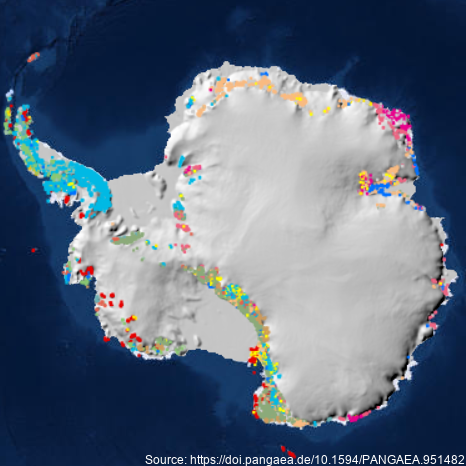
A dataset describing exposed bedrock and surficial geology of Antarctica constructed by the GeoMAP Action Group of SCAR (The Scientific Committee on Antarctic Research) and GNS Science, New Zealand. Legacy geological map data have been captured into a geographic information system (GIS), refining its spatial reliability, harmonising classification, then improving representation of glacial sequences and geomorphology. A total 99,080 polygons have been unified for depicting geology at 1:250,000 scale, but locally there are some areas with higher spatial precision. Geological definition in GeoMAP v.2022-08 is founded on a mixed chronostratigraphic- and lithostratigraphic-based classification. Description of rock and moraine polygons employs international GeoSciML data protocols to provide attribute-rich and queriable data; including bibliographic links to 589 source maps and scientific literature. Data are provided under CC-BY License as zipped ArcGIS geodatabase, QGIS geopackage or GoogleEarth kmz files. GeoMAP is the first detailed geological dataset covering all of Antarctica. GeoMAP depicts 'known geology' of rock exposures rather than 'interpreted' sub-ice features and is suitable for continent-wide perspectives and cross-discipline interrogation. Further details are provided at: Cox, S.C., Smith Lyttle, B., Elkind, S. et al. A continent-wide detailed geological map dataset of Antarctica. Sci Data 10, 250 (2023). https://doi.org/10.1038/s41597-023-02152-9 GET DATA: https://doi.pangaea.de/10.1594/PANGAEA.951482
-
Data of apparent ice thickness from airborne electromagnetic (AEM) surveys of fast ice in McMurdo Sound, Antarctica, carried out in Nov/Dec 2009, 2011, 2013, 2016, and 2017. Values are given for apparent thicknesses derived from both, in-phase and quadrature signals. The difference between both thicknesses is a scaled measure of sub-ice platelet layer thickness. Data are from east-west transects across McMurdo Sound, at fixed latitudes. Data were smoothed and interpolated onto a regular longitude grid (0.001 degree increments). More information can be found in Haas et al. (2021). Related Publication: Haas, C., Langhorne, P. J., Rack, W., Leonard, G. H., Brett, G. M., Price, D., Beckers, J. F., and Gough, A. J.: Airborne mapping of the sub-ice platelet layer under fast ice in McMurdo Sound, Antarctica, The Cryosphere, 15, 247–264, https://doi.org/10.5194/tc-15-247-2021, 2021