 Metadata Catalogue
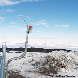
NOAA Global Monitoring Surface Ozone Network, Arrival Heights
Measurements of boundary layer concentration of ozone are made with insitu instruments that samples air continuously at Arrival Heights, Antarctica and is part of the NOAA Global Monitoring Surface Ozone Network.
Original measurements at Arrival Heights were made with a Dasibi Environmental Corp in situ analyser. This was replaced with a TEI-49c in situ analyser. The TEI-49c is owned by NOAA and operated by NIWA at Arrival Heights until October 2023. In October 2023 operation of the TEI was transferred to the USAP Arrival Heights laboratory along with operational responsibility (between NOAA and USAP).
This data set contains continuous UV photometric data of surface level ozone collected at 6m above ground level. Data records consist of UTC time, date, and processed ozone mixing ratio (parts per billion). Data is collected from global locations and is provided in 1 minute and 1 hour averages. Data are archived at the NOAA National Climatic Data Center (NCDC), but are produced and available from NOAA Earth System Research Laboratory (ESRL).
Instrument timeline:
- Dasibi 1997-2003
- TEI49c 2003 – October 2023
- TEI49i November 2023 -present at USAP Arrival Heights laboratory
GET DATA: https://gml.noaa.gov/aftp/data/ozwv/SurfaceOzone/ARH/
Simple
Identification info
- Date (Creation)
- 2023-08-14T17:18:10
- Date (Publication)
- 2023-08-14T17:18:10
- Citation identifier
- http://dx.doi.org/10.7289/V57P8WBF
- Presentation form
- Purpose
- To measure ozone concentration.
- Status
- On going
- Point of contact - Custodian, Owner, etc
-
Role Organisation Individual Electronic mail address Author McClure-Begley, A. audra.mcclure@noaa.gov Principal investigator Petropavlovskikh, I. irina.petro@noaa.gov Principal investigator Oltmans, S. samuel.j.oltmans@noaa.gov Publisher National Oceanic and Atmospheric Administration, Earth Systems Research Laboratory Global Monitoring Division. Boulder, CO ncei.info@noaa.gov
- Spatial representation type
- Topic category
-
- Climatology, meteorology, atmosphere
Extent
))
Temporal extent
- Time period
- 2022-12-23T00:00:00 2023-12-31T12:00:00
- Maintenance and update frequency
- Annually
- Date
- 2023-08-09T11:19:02
- Date type
- Last Update
- Keywords
-
- OZONE
- SURFACE OZONE
- K085A
- INSTALLATION
- GCMD Earth Science and Earth Science Services Keywords
-
- TROPOSPHERIC OZONE
- GCMD Platform/Sources Keywords
-
- ESRL STATIONS
- GROUND STATIONS
- GCMD Instrument/Sensors Keywords
-
- Spectrometers
- GCMD Locations Keywords
-
- GLOBAL
- ANTARCTICA
- ROSS ISLAND
- Resource constraints
-
Legal constraints Access constraints Use constraints Constraint application scope This data set conforms to the CC BY-NC Attribution License (https://creativecommons.org/licenses/by-nc/4.0/) License License Dataset
- Language
- English
- Character encoding
- UTF8
Distribution Information
- Distribution format
-
Resource lineage
- Statement
- Dataset lineage tracked extensively with all calibrations and calibration values monitored on a bi-monthly schedule. Raw data is always maintained to monitor lineage of data set.
- Hierarchy level
- Dataset
- Metadata constraints
-
Legal constraints Access constraints Use constraints Constraint application scope This data set conforms to the CC BY-NC Attribution License (https://creativecommons.org/licenses/by-nc/4.0/) License License Metadata
Metadata
- Metadata identifier
- urn:uuid/5d1a13cb-5c6a-479b-99a1-af384f60c4ec
- Language
- English
- Character encoding
- anyValidURI
- Metadata Contact
-
Role Organisation Individual Electronic mail address Point of contact National Institute of Water and Atmospheric Research (NIWA) dan.smale@niwa.co.nz
Type of resource
- Resource scope
- Dataset
- Metadata linkage
-
Name Linkage (URL) Protocol Function Description http://dx.doi.org/10.7289/V57P8WBF Complete Metadata
- Date info (Revision)
- 2024-08-22T23:09:58.856Z
- Date info (Creation)
- 2023-08-08T22:52:13
Metadata standard
- Format name
- ISO 19115-1
- Edition
- 2018
)))