Aerial Adelie Penguin Colony Images: Scanned Negatives and Digital Photographs of Ross Island and Victoria Land Colonies, Antarctica, 1981-Present
Simple
Identification info
- Date (Creation)
- 2023-01-19T15:46:37
- Date (Publication)
- 2023-01-19T15:46:40
- Presentation form
- Purpose
- To census Adélie penguin populations to provide data against which future population levels can be compared in order to monitor environmental change of the Antarctic Ocean ecosystem, both natural and anthropogenic
- Status
- On going
- Point of contact - Custodian, Owner, etc
-
Role Organisation Individual Electronic mail address Author Meredyth-Young, M. m.meredyth-young@antarcticanz.govt.nz Co-author Robinson, E. e.robinson@antarcticanz.govt.nz Co-author Hendrikx, J. j.hendrikx@antarcticanz.govt.nz Publisher Antarctica New Zealand adminteam@antarcticanz.govt.nz
- Spatial representation type
- Topic category
-
- Biota
Extent
N
S
E
W
))
Temporal extent
- Time period
- 1981-01-01
- Maintenance and update frequency
- As needed
- Maintenance note
- Initial commit
- GCMD Earth Science and Earth Science Services Keywords
-
- POPULATION DYNAMICS
- INDICATOR SPECIES
- FOOD-WEB DYNAMICS
- PENGUINS
- GCMD Platform/Sources Keywords
-
- HELICOPTER
- AERIAL PHOTOGRAPHS
- C-130
- GCMD Locations Keywords
-
- ANTARCTICA
- ROSS ISLAND
- Keywords
-
- VICTORIA LAND
- PENGUIN CENSUS
- PYGOSCELIS ADELIAE
- K850A
- Resource constraints
-
Legal constraints Access constraints Use constraints Constraint application scope Attribution-NonCommercial 4.0 International (CC BY-NC 4.0) Copyright Copyright Dataset
Associated resource
- Association Type
- Cross reference
- Initiative Type
- Project
- Language
- English
- Character encoding
- UTF8
Distribution Information
- Distribution format
-
Data quality info
- Hierarchy level
- Dataset
Report
Result
- Format name
- CAP-AU Compliance
- Metadata constraints
-
Legal constraints Access constraints Use constraints Constraint application scope Attribution-NonCommercial 4.0 International (CC BY-NC 4.0) Copyright Copyright Metadata
Metadata
- Metadata identifier
- urn:uuid/227f23a0-010d-4a44-91d9-634ece1075a7
- Language
- English
- Character encoding
- anyValidURI
- Metadata Contact
-
Role Organisation Individual Electronic mail address Point of contact Antarctica New Zealand m.meredyth-young@antarcticanz.govt.nz
Type of resource
- Resource scope
- Dataset
- Metadata linkage
-
Name Linkage (URL) Protocol Function Description Complete Metadata https://antcat.antarcticanz.govt.nz:/geonetwork/srv/api/records/227f23a0-010d-4a44-91d9-634ece1075a7 Complete Metadata
- Date info (Revision)
- 2024-07-17T04:43:06.582Z
- Date info (Creation)
- 2023-04-05T20:25:01
Metadata standard
- Format name
- ISO 19115-1
- Edition
- 2018
Overviews
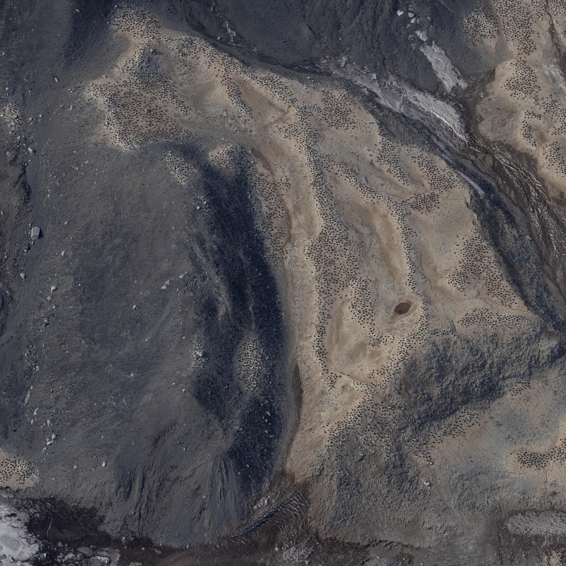
Cape Bird 2023
Spatial extent
)))
Provided by

Associated resources
Not available